


boucle lauterie

philou68
User
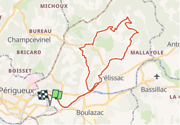

Length
24 km

Max alt
232 m

Uphill gradient
419 m
Km-Effort
29 km

Min alt
84 m

Downhill gradient
419 m
Boucle
Yes
Creation date :
2022-05-01 07:00:47.884
Updated on :
2022-05-01 11:32:35.186
4h30
Difficulty : Easy

FREE GPS app for hiking
 SityTrail
IGN / Geographical institutes
SityTrail Plus
The world is yours!
About
Trail Walking of 24 km to be discovered at New Aquitaine, Dordogne, Boulazac Isle Manoire. This trail is proposed by philou68.
Positioning
Country:
France
Region :
New Aquitaine
Department/Province :
Dordogne
Municipality :
Boulazac Isle Manoire
Location:
Boulazac
Start:(Dec)
Start:(UTM)
322619 ; 5005809 (31T) N.
Comments